Suitable for track precision measurement based on GNSS reference station control network; At the same time, it is also suitable for the survey of the railway line overhaul.
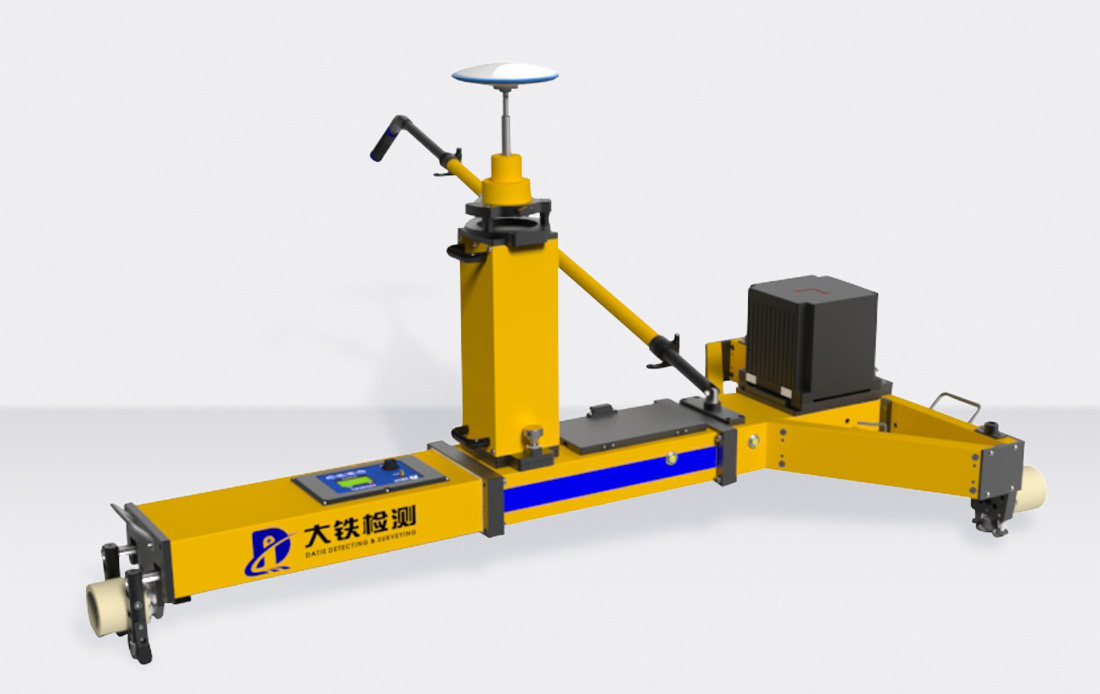
GNSS Inertial Navigation Type Orbit Geometry Measuring Instrument (AIS800G) is a fast and mobile precision measurement product of orbit geometry using Beidou and GPS assisted inertial navigation system. The biggest highlight of the product is that the "absolute + relative" measurement of the universal speed railway track is completed based on satellite control and GNSS reference station.
Novel operation mode
The combination mode of GNSS plus inertial navigation is innovatively introduced into the existing line track inspection, which is simple in field operation, fast in hand, and does not require professional training.
Quick and easy operation
Products adopt modular design, easy to disassemble and assemble on the road; The software interface is simple and friendly, one-click data processing, and fault-tolerant mechanism is perfect.
High measurement accuracy
System gauge, ultra-high repeatability detection accuracy up to 0.2mm, track, high and low, long and short wave irregularity repeatability up to 1mm repeatability measurement accuracy, based on CPI/CPII/ global coordinate system absolute detection accuracy up to 15mm.
High measurement efficiency
The measurement operation can be completed by implementing the equipment on the track, and the implementation speed is not more than 20km/h, with no low speed limit. Each skylight can operate 6~10km (push, 2 hours skylight).
Advanced data processing
With high precision inertial navigation system as the core, advanced multi-source data fusion technology is applied to achieve centimeter-level absolute detection accuracy and submillimeter-level relative detection accuracy in dynamic mode.
Strong adaptability
The system has good adaptability to climate and mechanical structure.
Precision index | ||
gauge | Detection range (1000106 7152 0/24160 0166 standard 1435, customizable 8/76) | 1400mm~1480mm |
Line measurement repeatability | ≤0.2mm | |
Gauge change rate measurement repeatability | ≤0.03% | |
Ultra | Detection range | -225mm~225mm |
Line measurement repeatability | ≤0.2mm | |
Torsion measurement repeatability | ≤0.375mm | |
Odometer (photoelectric counter) error | ±1‰(GNSS real-time modification) | |
GNSS mileage | 2cm,No accumulation | |
Direction of trajectory | 2mm/10m | |
height | 2mm/10m | |
Main parameter resolution | ||
Gauge, super high | ≤0.01mm | |
Track direction, height | ≤0.01mm | |
Absolute position parameter | ≤0.0001m | |
Relative position parameter | ≤0.01mm | |
Basic parameter | ||
Temperature range | -25℃~+50℃ | |
Relative humidity | 0~95%,non-condensing | |
Operational efficiency | 3~5km/h(people push) | |
Inertial data update frequency | 200Hz | |
Working hours | >8h | |
System absolute accuracy | Better than 15mm (excluding GNSS reference station error) | |
Operation mode | Cycle dynamic continuous operation | |
The "absolute + relative" measurement of the general speed railway below 160km/h, the technology forms a standard to guide the fine measurement and stamping operation of the whole road.
Subdivision application scenario: universal speed railway line retest; Accurate measurement of railway lines with normal speed; Speed up the existing railway; Rough adjustment of new ballast railway lines; Scenarios such as rapid detection of existing track.
Application route: Kuka Railway in southern Xinjiang; Beijing-shanghai Line, Beijing-ninth Line, Handi Line, Shanghai-Kunming Line; Stone economy line; Jiujingqu Railway; Great Hanyang tram track acceptance and so on.


Call


South China and Central China Service Hotline:
13928860524
East China and North China service hotline:
17727764409
After-sales service:
18102594604